
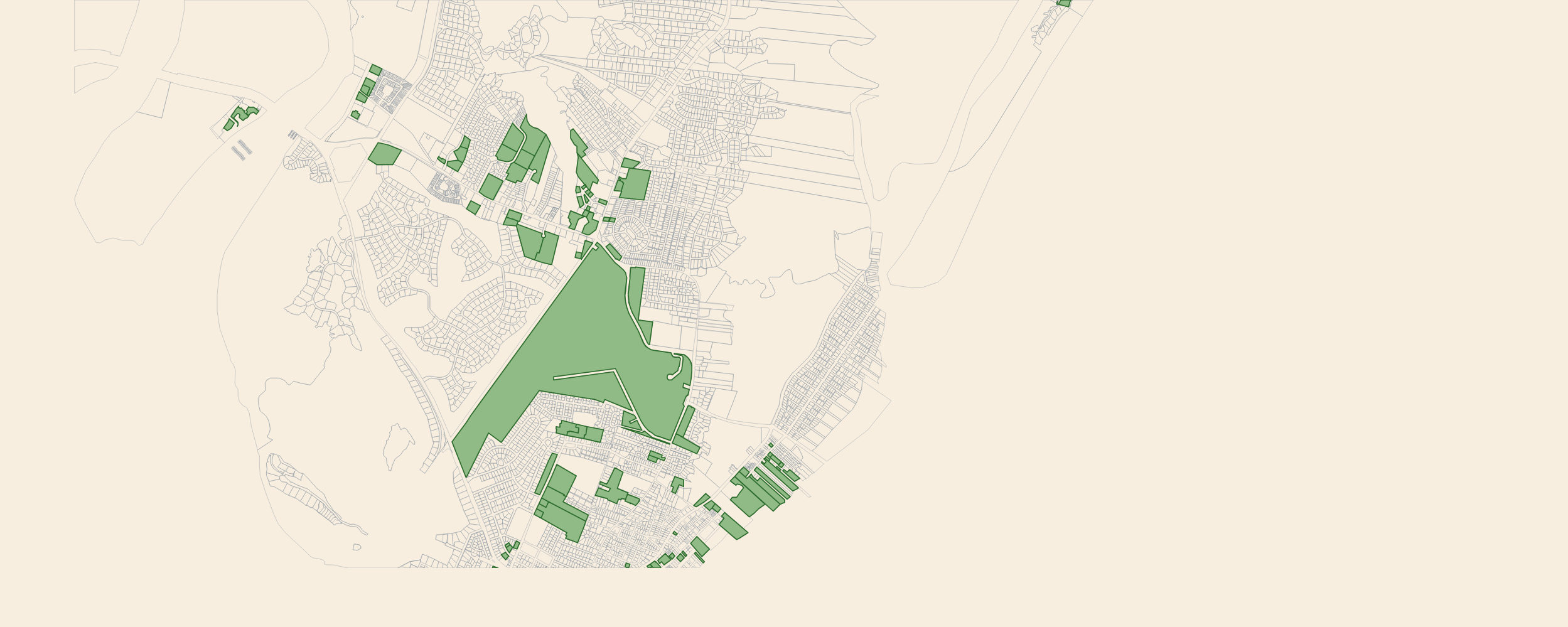
As of its September 2, 2026 refresh, Regrid’s data store lists 46,483 parcels for Glynn County, Georgia. Our Glynn layer carries 51,317 — 110.4% of theirs. When our coverage sweep flags a county that far above Regrid’s count, we take it apart record by record to make sure we aren’t the ones double-counting. Glynn came back clean. The surplus isn’t our noise; it’s 6,390 of the county’s own tax accounts that Regrid doesn’t ship — the parcels filled green on the map above — condominium and villa units, hotel condominiums, privately owned airport hangar lots, golf-fairway lots, and recorded-but-undeveloped subdivision lots. Nearly one record in eight. Together they belong to 3,988 owners and carry $2.52 billion in assessed value.
One polygon, 145 owners
Take The Beach Club, the oceanfront resort at 1440 Ocean Boulevard on St. Simons Island. On the county’s parcel map it is one polygon, PIN 04-08488 — one shape, one feature. But that polygon carries 145 separate tax accounts on the county’s roll: Glynn’s assessment records list account 014-057, unit 219, owned by Sarah McDade for $504,000; account 014-008, owned by Sue Stephenson for $735,000; account 014-001, owned by 101 BC LLC for $420,000; and 142 more — 145 owners, 145 assessments, $91.7 million of real estate, billed by the county on 145 separate tax bills. A dataset built one-record-per-polygon ships one record for it, tagged with whichever account the county listed first.
Why feature-grain datasets have this hole
Glynn publishes its cadastre as two kinds of product: the parcel map — one polygon per physically mapped lot, with platted units drawn on the master polygon — and the assessment records, which tax each unit individually. The units reach us through the county’s own systems: the Schneider Beacon roll (52,977 records in its staged export), the county’s public GIS parcel service (46,510 records live today), and a dedicated reference table of platted units keyed on the county’s 7-character plat-style account numbers — 014-057, 002-114, 000-958. The polygons are the easy part: they download as ready-made geometry. The units live in keyed tables that have to be joined, reconciled, and stacked.
Regrid’s own Glynn coverage report describes the model it can’t escape. On every one of the 46,483 records the September 2026 refresh ships, the fields that would mark a second account on a polygon are empty: Parcel Address Unit 0%, Number of Living Units 0%, Parcel Account Number 0%, Tax Year 0%, Parcel Stack UUID 0%, and so are Plat, Book, Page, Block, and every condominium/fee/leased property-type and split land-and-improvement value field. It is a product-grain decision, not sloppiness about Glynn: every field they do carry is 96–100% populated, from owner and situs address to parcel ID and zoning. But one feature per assessor polygon means every condominium unit, villa lot, hangar lot, and platted subdivision lot the county draws on a master polygon is folded away by construction.
| Glynn County, GA | Regrid (refreshed 2026-09-02) | landrecords.us |
|---|---|---|
| Parcel records | 46,483 | 51,317 |
| The Beach Club, 1440 Ocean Blvd | 1 record, 1 owner | 146 records, 145 owners |
| Assessed value visible at The Beach Club | one unit’s share | $91,686,600 across 145 units |
What the 6,390 missing records are
Classifying every stacked record in the county by what it is, not where it is:
| Stacked record class | Footprints | Records | Owners | Assessed |
|---|---|---|---|---|
| Individually owned units — condo, villa, hotel, hangar, and golf-lot accounts | 267 | 4,192 | 3,762 | $2.29 B |
| Platted, single-owner subdivision lots — recorded plats still in a declarant’s hands | 11 | 866 | 12 | $47.9 M |
| Other stacked pairs — duplex and patio pairs, consolidated-roll footprints | 718 | 1,317 | 213 | $170.1 M |
| Common-element-only stacks | 14 | 15 | 14 | $7.2 M |
| Total | 1,010 | 6,390 | 3,988 | $2.52 B |
Of the 6,390, 5,322 carry an owner name and 5,858 a positive assessed value, and 4,382 are keyed with the county’s plat-style map-lot account numbers that exist only on the unit records — the county’s own numbering proves these are separate tax accounts, not renderings. The use codes read like a resort market: 3,670 residential units, 354 golf-fairway lots, 351 commercial, 309 retail, and 163 maintained-grass common elements.
And they aren’t scattered noise around the county line. The largest stacks are places anyone who vacations on the Golden Isles knows by name:
| Stacked footprint | Units missing | Owners | Assessed |
|---|---|---|---|
| Golden Isles Gateway Tract R-6, 3102 Bergen Woods Dr | 195 | 1 | $21.1 M |
| Barnes Plantation Condos, 1704 Frederica Rd | 182 | 156 | $49.4 M |
| Retreat at Grande Lake (SREIT), Walden Shores Ln | 162 | 1 | $16.1 M |
| Villas by the Sea, 1175 N Beachview Dr | 159 | 148 | $50.2 M |
| The Beach Club, 1440 Ocean Blvd | 145 | 144 | $91.7 M |
| Malcolm McKinnon Airport hangar lots, 1501 Demere Rd | 137 | 101 | $41.3 M |
| Harbour Oaks, 614 Mallery St | 117 | 116 | $54.0 M |
| Island Retreat Condos, 2500 Demere Rd | 105 | 88 | $34.2 M |
| The Cloister Ocean Residences, 10 & 50 Dune Ave | 83 | 80 | $90.7 M |
| The Grand, 1400 Ocean Blvd | 80 | 79 | $110.3 M |
| … plus 990 more stacked footprints, down to two records each | 3,976 |
Concrete accounts, each a real Glynn tax bill, each absent from Regrid’s Glynn file:
002-114— 10 Dune Avenue, unit 1432, LAFF COR LLC, $1,640,000 — one of 83 separately PINned condominium units at the Cloister Ocean Residences.000-958— 126 Sky Spaces Court, KIRBY INVESTMENTS LLC, $101,000 — a privately owned hangar lot on the county airport’s single consolidated polygon (137 lots, 101 owners). Neighbor000-991, 109 Happy Hangars Road, belongs to Franklin R Dean for $39,900.015-067— 347 Walden Shores Lane, SREIT Retreat at Grande Lake, $89,900 — one of 162 recorded, platted, individually valued lots under one resort’s parent polygon.
What this is not
Reading 110.4% of a competitor’s count is exactly the kind of number we investigate as a defect in ourselves until it proves otherwise. Four controls, all run against the county’s own numbers:
- Not duplication. The squash audit on today’s layer finds 0 foldable rows. The two county channels share only 39 normalized PINs across ~23,000 ids each — the county’s AGOL map-numbering and Beacon’s plat map-lot numbering are disjoint systems, complementary publications of the same roll, not copies of each other. Where the same tax account does appear in both, the merge keeps one row.
- Not stale vintages. Both Glynn channels carry
taxyear2024 — the same vintage as the February 2025 baseline this audit reconciled against — and the stacked units sit on their master polygons (0.8–1.0 containment), not beside them: a redraw-offset artifact would show partial overlaps and shifted centroids, and the pairwise analysis found none at scale. - Not county growth. The live parcel service answers 46,510 records today against the 46,494 we staged on October 15 — plus 16, against a gap of nearly 5,000. And Regrid’s new September 2026 file moves the same way the map does: its 46,483 count sits within 27 records of the county’s live polygon layer, a feature-grain copy of that map with more polygons and still none of the county’s per-account records.
- Same-grain agreement. Fold our records down to physical footprints and Glynn reads 44,927 vs the 45,323-record baseline Regrid carried at audit time — within 0.9%, with the margin running Regrid’s way (they split ~396 footprints we coalesce). The arithmetic closes exactly: 51,317 − 45,323 = 5,994 = 6,390 stacked unit records − 396. The deficit number is, if anything, conservative.
How we model it: parcel stacks
Our schema represents platted units the way the assessor does — as a stack. The master record carries the shared polygon PIN (here 04-08488, the county’s map number for the resort parcel, published in its parcelid2); every other tax account on that polygon keeps its own county account number as its parcelid, with its own owner, situs, use code, and assessment; and each child’s parentid carries that shared PIN back, tying the family together. The PIN, not the account number alone, is what keys the stack — because Glynn’s plat-style numbers are unique within a plat map, not county-wide: account 014-008 exists twice, as unit 108 at The Beach Club and as Courtyard Villas A8 in St. Simons. Children are drawn on the master polygon, so every unit lands on the map. Here is the actual Beach Club stack as it appears in our dataset:
The 1440 Ocean Boulevard stack, drawn from our production records: the master publishes the shared map PIN in parcelid2, each of the 145 unit records keeps the county’s plat account as its parcelid and points back at the PIN through parentid.
Why our collection method finds every account
The gap comes down to what a pipeline treats as the unit of truth. If the unit of truth is a polygon, platted units are invisible by construction. Ours is the tax account, and three habits of our pipeline follow from that:
- We acquire every layer, not just the geometry. For Glynn that means the county’s AGOL parcel fabric and the CAMA reference table of platted units and the Beacon assessment roll — and our LLM-driven harmonization identifies the key that links each unit back to its polygon, on either side of the relationship.
- Merges must never lose an account. The step that consolidates sources into one county layer enforces a measurable invariant: consolidation may not reduce the number of surviving tax accounts. Our published Glynn union — 51,317 — sits between the county’s own two channel counts, 46,510 and 52,977, with nothing dropped to get there.
- We reconcile against the assessor, not against other vendors. Benchmarking vendor-to-vendor inherits this blind spot wholesale: measured at feature grain against Regrid’s baseline, our Glynn layer scores a boring 99.1% and nobody learns anything. Measured against the county’s roll, account by account, “over-coverage” resolves into 6,390 named developments and named owners.
None of this is hand-wired. The schema map below is drawn automatically from the harmonization views our pipeline wrote and stored in our catalog — the same way we draw it for every county. All four of Glynn’s acquired datasets are there: the parcel fabric, the address layer, and the zoning layer, and — in the REFTABLE section — the CAMA platted-unit reference table, where the unit’s 7-character map-lot account number parcel_id maps onto parcelid and its gis_pin onto parcelid2. In the PARCEL section, the fabric’s parent_pin maps onto parentid. Those are the wires down which 6,390 unit accounts enter the dataset. Glynn’s live record counts, acquisition dates, and field fill rates are on its county coverage page.

Glynn’s complete schema map, regenerated October 2026 from the live harmonization views in our catalog: source columns on the left, harmonized entities in the middle sections, and the published parcel schema at the top. Scroll inside the figure — the REFTABLE section is where the platted-unit accounts enter the dataset.
Regrid’s Glynn count has moved since we ran this audit — 45,323 in the February 2025 baseline, 46,483 after the September 2026 refresh — but every record of that growth is a polygon the county drew, not an account it taxes: the unit-account fields are still all zero, and the ~6,390 stacked records stay out of reach until a feature-grain product adopts the tax account as its unit. Ours will keep reading above 110% of theirs — a number that is evidence about Regrid’s coverage, not about ours. If your work touches condominiums, fractional resorts, hangar lots, or recorded-but-unsold plats — ownership outreach, valuation, title research, lending — a feature-grain dataset isn’t showing you a smaller version of the market on St. Simons. It’s showing you a different one, in which $2.52 billion of separately owned, separately taxed real estate doesn’t exist.
Glynn’s datasets, vintages, and per-field coverage are on its coverage page; compare us on coverage, fields, and price on our home page or browse the US Nationwide Parcel Dataset. Email hello@landrecords.us — we’re happy to run this same analysis for any county you care about.